Вигинский В.А. Новейшие тектонические режимы и позднеальпийская геодинамика Азово-Черноморского бассейна в свете проблемы происхождения впадины Чёрного моря // Разведка и охрана недр.- 1996.- № 10. С. 15-24.
г
Viginsky V.A., 1996Viginsky V.A.
(IGIRGI, Moscow)
New tectonic modes and Late Alpine geodynamics of the Black Sea region (a problem of an origin of a cavity of the Black sea)
For the time being Azov and Black Sea basin and its surroundings draw attention of many researchers because of the convenient geographic position and, consequently, of the great interest in mineral resources exploration. A rather developed coastal zone needs adequate geological, tectonical and geodynamical schemes to forecast the dangerous geological processes.
Data available make it possible to form a quite non-contradictory pattern of the region tectonical composition and the Late Alpine development. Reconstruction of the Azov and Black Sea basin geodynamical situation is of great interest especially in terms of the regional Cenozoic structure formation. Numerous attempts to exercise such reconstructions are lacking in completeness. Still there exist the region geodynamical patterns for the pre-Cenozoic progress stages. As a rule they are consistent enough and, from the author's point of view, describe the regional earth crust formation objectively, according to the data available [1-4]. For all that the geodynamical schemes for the Late Alpine stage progress of the Azov and Black Sea region are strangely indistinct. This paper tries to fulfil the most possible adequate regional Late Alpine progress analysis and to determine its modern geotectonical position, based upon the data available and the author's previous investigations.
Previous notions on the Black Sea basin origin
The Black Sea deep basin origin problem directed researches attention since the end of the 19 century. Appeared in the early works by E.Suess in 1886, the problem has been discussed uninterruptedly and for the time being there are three main complete conceptions of the Black Sea deep basin origin.
The first one assume the basin relic origin considering the basin as a remnant in the Alpine folding belt. Moreover there were assumptions that the basin was an ancient "matrix geosyncline depression" [5] as well as a fragment of the most ancient oceanic crust [6,7]. Such a conception is dubious as indicated by the latest data on the deep basin structure and the sediment cover structure [8,9]. As revealed by the seismic reflection profile recording, carried out by "Soyuzmorgeo", the Black Sea deep basin was superimposed on the surrounding structures at least during the Cenozoic period, since that time the basin is progressing actively, broadening and absorbing the circumbasin formations.
The second conception assumes a new formation origin of the basin. In particular notions on the most recent basin origin were widespread for a long time. N.I.Andrusov found Chaudin terrace remnants on the Dardanelles coast and, dredging the Black Sea bottom, a freshwater mollusc Dreissensia polymorpha in 1905. Accordingly he arrived at a conclusion on a freshwater type of so called Eucsinian basin, which preceded the modern sea. Based upon these investigations the time of the Black Sea basin origin was believed to be Late Neogene. Some authors assume the Early Quaternary age of the basin [11, 12]. Such notions are not confirmed by the empirical data collected for the time being.
Considering the hypothesis of the consequent Black Sea basin new formation one should dwell on the question of the basin origin and progress mechanics. There are two the most widespread hypotheses. The first one deals with the rapid vertical crust movement predominantly (within both fixism and mobilism paradigms), the second one deals with the crust spreading predominantly (that is a riftogene origin). The latter is based either on the idea of the riftogene rupture, followed by the "granite metamorphic ' crust gapping within the basin, or on so called suboceanic basin aerial spreading idea (the aerial riftogenesis, [18]). The aerial spreading hypothesis was designed to overcome discrepancies between the primitive plate tectonic patterns of the suboceanic mediterranean basins genesis (the Black Sea basin being one of them) and the real geological and geophysical data. In such a case they cite spreading structures within the basins and so called "tectonic density" (orogeneses, folding systems) along their periphery as the riftogenesis indications. The Zavaritzky - Benioff zones are believed to be an additional indication because they compensate partially the sea flour spreading owing to the subduction.
The crust submergence causing the Black Sea type origin of the suboceanic deep water basins is postulated most legibly within the fixism "basification" [8] and the "eclogitisation" [19,20] of the Black Sea deep basin crust.
This brief review of the Black Sea deep basin origin and progress conceptions shows very obviously their contradictions. This paper tries to overcome such a problem.
Tectonic structure features
An important feature of the Azov and Black Sea region is its position within the ancient Tethys ocean and the surrounding paleocontinents, which were progressing rapidly during Phanerozoic time. The above- mentioned contradictions between the conceptions of the region origin and its Late Alpine progress are accounted by the complex jointing of various tectonic structures (from the ancient platform to the recent basin geostructures and the orogenic surroundings) marked by extraodinary heterogeneity as well as different coverage of the areal exploration.
The latest extensive geophysical works such as gravimetric, magnetic and heat flow studies, seismic works such as refraction and reflection recording, deep water drilling results [21-25] made it possible to revise problems of the Azov and Black Sea region progress in terms of the Western Mesotethys shutting and, consequently, problems of its tectonic structure features (fig.1).
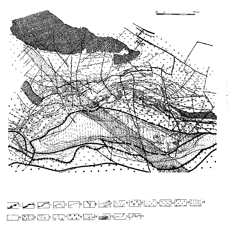
Fig.1
Tectonic scheme of the Azov and Black Sea region. Boundary: 1 - between the plates (presumable one is dotted); inside the plates: 2 - between the different crust type areas (presumable one is dotted); 3 - between the ancient and recent platforms; 4- inside the recent platform - between the areas with different age of the final basement folding (presumable one is dotted); faults: 5 - inside the platforms (presumable one is dotted); 6 - transition transverse fault zone (presumable one is dotted); 7 - the Arkhangelsky - Andrusov lineament (Thornquist line fragment ?) (presumable one is dotted and hatched);Eurasian plate: continental platform: 8 - ancient (East European) platform of the pre-Baikalian age of the non-subdivided basement final folding;
Scythian and Misian (recent) platform: 9 - the Baikalian basement areas; 10 - the Caledonian and Hercynian non-subdivided basement areas 11 - the Kimmerian basement areas; 12 - the Laramian basement areas;
suboceanic (Black Sea) platform: 13 - presumably the Laramian basement areas (the second layer ?);
Eurasian frontal area of the transition earth crust: 14 - with the Laramine effusive basal sediments on the subcontinental (?) crust; 15 - a) the Baikalian massif covered by the Laramine effusive sediments on the suboceanic (?) crust; b) the block with the Laramine effusive sediment basement on the subcontinental crust;
Arabian plate: frontal area on the transition (suboceanic) earth crust: 16 - frontal zone on the post-Baikalian non-subdivided basement covered by the obducted (oceanic) Laramine ophiolites; 17 - frontal zone on the Baikalian basement;
Anatolian continental recent plate with non-subdivided basement: 18 - non-subdivided deposits of the Anatolian plate; 19 - slightly deformed sediment cover base isohypse; 20 - folded basement outcrops; 21 - linear thinning out of the continental crust (presumable one is dotted); 22 - existing coastal line.
When accomplishing the region tectonic zoning the author based on the theory couched by Yu.A.Kosygin and V.A.Kulyndyshev [26]. The author tried to evade confusion of the geometrical and the "regime" (that is according to the process type) zoning principles. So the author followed the rules of the traditional tectonic cartography approach, worked out by N.S.Shatsky and N.P.Kheraskov long ago [27-29] as strict as possible.
There are distinguished tectonic elements (structural and substantial complexes) of different rank (fig.1). Eurasian and Arabian plates together with the separating Rodopy - Pontian suture (subduction paleozone) as well as Arkhangelsky - Andrusov lineament, which seems to be a Thornquist - Zagross lineament fragment, should be regarded as superregional (planetarian) structures. The above- mentioned suture is marked by the plate frontal areas, which seems to be composed of the collision blocks of the transition crust type , correspondingly by subcontinental crust in terms of I.P.Kosminskaya and suboceanic crust.
They are composed of the Laramine effusive deposits, covered by slightly deformed Cenozoic sediment blanket [24] on the Eurasian plate and by the Laramine rootless ophiolites overthrusting the Anatolian plate structures, which are not subdivided in this paper, on the Arabian plate. The Laramine effusives are studied in detail within the Burgas depression and the Adjaro - Trialet trough, the Laramine ophiolites seem to be of the oceanic type with high titanium content. The Eurasian effusive Late Cretaceous complex seems to be of the island arc subduction
origin , marked simetimes by the ophiolites with low titanium content [30]. The transition earth crust type of the plate frontal areas does not contradict the seismic data available [21,22].The Arkhangelsky - Andrusov lineament is actually a wide belt of the north - west strike, being transit to the above- mentioned plates. The lineament is marked by linear flexures, linear pinching of various Cenozioc complexes, chains of microbasin within the Cenozoic deposits of the Black Sea basin. Outside the deep sea basin the north - western Black Sea shelf and the land part of the East European platform are marked by a series of contrast magnetic anomalies [21,31], one of them corresponds to volcanic Ilychevsk elevation, which makes it possible to interprete in such a manner some of the anomalies for certain. Distal structures of the Ukrainian shield are also marked by the magnetic anomalies. This lineament seems to be most active in the Cretaceous time. The recent movements fixed the lineament as a steep flexure bending to the West Black Sea basin [33] together with a heat flow contrast anomaly [22]. The Arkhangelsky - Andrusov lineament strike turns into the Thornquist line in the North - West and into the Zagross lineament in the South - East.
The continental and suboceanic (Black Sea) platforms are distinguished within the Eurasian plate besides the above- mentioned frontal zone. The suboceanic one
is characterised by pinching out of the continental crust and a deposit blanket base presumably of the Laramine age. The deposit base is believed to be the second earth crust layer of the oceanic type characterised by the longitudinal wave velocity from 4,0 to 6,7 km per sec. [21,22].The continental platform is subdivided into the ancient East European platform and the recent Scythian and Misian plates. The recent plate boundary is feebly marked, so they are amalgamated as a Scythian - Misian platform (fig.1). The boundary between the ancient and recent platforms is marked by a deep zone retraced to the crust. The zone position is still debatable. This paper holds the position given by G.M.Aladatov and others for the Kuban territory [34], by F.P.Borkov and others for the Azov Sea [35] and by O.I.Rogoza and others for the north - western Black Sea shelf and the surrounding land [22].
There are areas of different folding basement age within the Scythian - Misian plate. Moreover both the Baikalian block areas and the Caledonian - Hercynian and the Kimmerian block areas are outlined there [22,31,36-38].
The Alpine folding areas are not outlined within the Azov and Black Sea tectonic elements, this is an important characteristic feature of the region tectonic zoning. The Alpine folding areas have been interpreted as corresponding to the recent orogenesis areas like the Caucasus until recently. The latest data on the Alpine complex deformation of the Major Caucasus indicate that there is no any continuous holomorphyc folding within the orogenesis [39]. The holomorphyc folding is of an echelon character, connecting with little anticlinoriums (sometimes
brachyanticlinoriums) or with borders of the gentle structural steps. The folding areas are surrounded by spacious synclinorium areas which are characterised by rather less complicated morphology. The holomorphyc folding seems to mark the great faults, forming an orogen frame there. The Crimean Alpine deposits are of the same folding type [38]. So the above- mentioned mountain structures are actually the epiplatform orogenies, while the Major Caucasus is composed, in particular, of the blocks dated both by the Baikalian and the Kimmerian basement age (fig.1). The Scythian - Misian platform basement is dated by different ages in the different parts. The distal part, bordering the suboceanic Black Sea platform, seems to consist of the Baikalian age rocks. This is confirmed by data on the structure of the East Black Sea rise (Shatsky rise in terms of D.A.Tugolesov) stretching to the east to the Dziruli land protrusion, as well as data on the structure of the western Black sea and the land surroundings [31]. The Dziruli protrusion seems to consist of the Baikalides [40]. The Scythian - Misian platform basement is composed of the alteration of the Caledonian - Hercynian and the Kimmerian rocks to the north of the Baikalide zone, seemingly due to the tectonic processing of the initial Baikalide platform basement.
The recent tectonic conditions and the Late Alpine tectonic progress reconstruction
The previewed Azov and Black Sea region structure features facilitate to outline the Late Alpine formation process for the above- mentionsed structure [fig.1] . A preliminary description of the existing regional tectonic conditions is necessary for such outlining[33]. The conditions may be characterised in a condensed form by the Cenozoic tectonic localisation in space and time (fig.2).
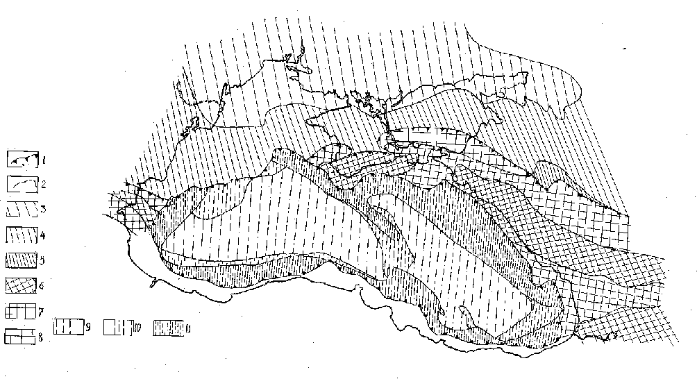
Fig.2
The Azov and Black Sea basin Cenozoic tectonic modes map. 1 - modern boundaries of the different tectonic modes areas; 2 - tectonic modes areas boundaries for different Cenozoic structure formation stages; the platform tectonic mode area: 3 - ancient platform; 4 - epihercynian plate; 5 - the platform mode area established in the early neotectonic stage time; the orogenic tectonic mode area: 6 - established in the early orogenic initial phase time (from the Early Cenozoic); 7 - established in the early orogenic stage time (from the Late Eocene - Early Oligocene); 8 - established in the Recent time (from the Early Meotian); the deep sea basin tectonic mode area: 9 - from the Early Cenozoic; 10 - from the Early Oligocene; 11 - from the Early Meotian (from the early recent stage time).The platform conditions are manifested in the northern Azov and Black Sea basin, that is the north - western Black Sea (including Bulgarian, Rumanian and the north - western Black Sea shelves) and the northern parts of the Crimean peninsula, Azov sea and Kuban territory. The ancient East European plate and the recent epihercynian Scythian and Misian plates are outlined there as well as a zone which originated as an epiplatform orogenic foredeep in the Oligocene to Miocene time and involved in the platform conditions in the recent time [41,42]. This territory for the most part is characterised by the condenudation to consedimentation conditions in term of the intensity ratio of the tectonic and denudation processes.
The recent orogenic conditions areas, such as the Caucasus, the Crimea, the Stara Planina and the surrounding foredeeps, are characterised by the orogenic complex sedimentation, namely by the orogenic foredeep upper molasse consisting as a rule of merging river delta fans from the elevated mountains of the Caucasus, the Crimea and the Stara Planina. The orogenic areas are tending to elevate within the region, which results often in the overcompensation of the orogenic foredeeps such as the East Kuban and the Almin depressions and in the increase of the mountain massifs dismemberment. That is why the orogenies may be treated as conerosion within the arches and as consedimentation within the depressions in terms of the intensity ratio of the tectonic and denudation processes.
Both the true orogenic zones of the arch structures and the orogenic firedeeps are outlined within the territories characterised by the orogenic conditions in the recent time (fig.2). The zones are marked by the evident elevation conditions, conerosion conditions in whole of the recent time in terms of the ratio of the tectonic and denudation processes as well as by rather great earth crust penetrability together with compact Caucasian vulcanism and by the orogenic stage deposits fragmentation. The orogenic conditions seem to be formed in the initial orogenic stage in the Palaeocene to Eocene time in some parts of the region [22,41,43]. The orogenic foredeeps were involved in the orogenic process later on, in the Maikopian time, they are characterised by predominant sinking, numerous orogenic molasses which were correlate to the elevating massifs of the true orogenic zones. The earth crust permeability and the vulcanism are also of the high intensity and compactness. Some parts were involved in the orogenic activity in the recent epoch only, beginning in the Emotion time.
The deep sea basin conditions are the third type of the Azov and Black Sea region tectonic conditions. Such conditions existed within the Black Sea basin in the recent time, when the basin was restricted by the Black Sea continental slope along its periphery.
The Black Sea bottom relief is rather smooth, the maximum water depth is 2244 meters, elevations relative heights are reaching several hundreds meters. Such a rather gentle bottom surface is reflecting the great regional subsidence intensity together with a slight movement differentiation. According to DSDP site 380A data the recent sediments thickness is 860 m. The great sedimentation rate does not compensate the regular Black Sea bottom sinking. This peculiar feature of the basin sedimentation is exhibited in the sediment infilling character. The upper stage sediments consist of the terrigenous silt, clay layers, carbonates interbedded with the turbidites [25] of the Meotian to Quartenary age in terms of L.I.Lebedev and others [20]. At the same time the turbidites do not contribute considerably to the Black Sea basin sediments infilling except for the peripheral parts neighbouring the great river systems, where such rivers as Danube, Don, Kuban, Bzyb, Kodori, Rioni, Kelkit are forming thick delta fans [22,23].
The total recent deep sea basin subsidence seems to manifest a common Cenozoic region tendency. The seismic data analysis makes it possible to retrace the Black Sea basin formation through the whole of the Cenozoic time [23,24]. The Black Sea originated as a single basin in the Late Eocene and the Early Oligocene time (fig.2). After the single basin origination the deep sea basin mode (DSBM) prevailed there, which is confirmed by the deposits of the Upper second seismic layer (Pg1 - N1 3 s) in the DSDP site 380A as well as the basin sediments infilling character, presumably reflecting the intensive though not compensated sinking in the Oligocene to Miocene time. The two deep water basins seemed to exist during the early basin formation stages, that is the Palaeocene to Eocene time. These were the East and the West Black Sea basins separated by the ablation zone within the Andrusov swell and the Arkhangelsky rise (the Arkhangelsky - Andrusov lineament, fig.1).
The elevation zone forming presumably the shelf areas existed along the Maikopian periphery of the Black Sea deep basin. The Oligocene to Miocene downwarping belt (namely the Sorokin and Tuapse foredeeps) stretched within the northern part of the zone [23,24] probably connected with the active formation of the Crimean and Caucasian orogenies. The subsequent Black Sea basin progress was accompanied by its broadening and superimposing on the above- mentioned orogenic foredeeps in the recent time together with their recent structural pattern change.
This analysis makes it possible to outline areas with the different time intervals for the deep sea basin mode establishment [33] within the recent DSBM zone (fig.2). In such a manner several stages are fixed. These are the pre - Maikopian stage when the two deep sea basins (the West and the East) seemed to exist in the Black Sea region; the Oligocene to Miocene stage characterised by the single Black Sea deep basin formation; the recent Meotian to Quaternary stage of the subsequent Black Sea deep basin broadening and the establishment of the deep sea basin mode within the existing sea borders.
So it seems to be the Early Palaeocene time when the East and West Black Sea basins originated, more or less similar to the existing basins. During the Cenozoic time there was a progressive broadening of the Black Sea basins which amalgamated into a single basin in the Maikopian time. This is confirmed by the transgressive Cenozoic sediment infilling of the basin root floor. In spite of the prolonged lateral Black Sea basin broadening there is no evidence of the earth crust stretching such as the absence of listric faults and graben-like structures or the transgressive infilling of the basins. The Black Sea basin sediments are accumulating too slowly to compensate its sinking
. For all that there is evidence of the surrounding structures progressive involvement into the downwarping process together with their structure change. Such a process is evident in the East Black Sea basin more than in the West one.Paleotectonic reconstruction within the Black Sea basin recent structure formation analysis makes it possible to define the regional tectonic pattern for the period prior to the Cenozoic structure formation stage (fig.3).
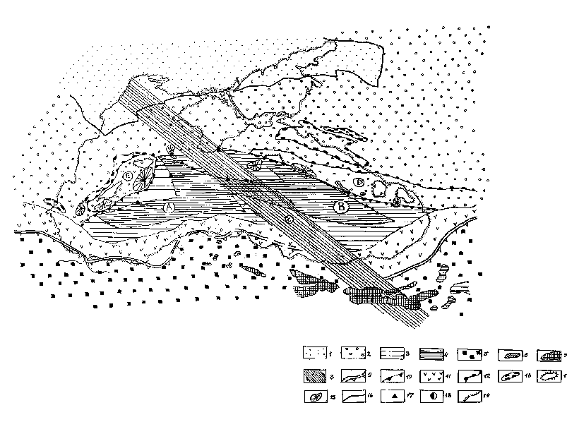
Fig.3
The Late Cretaceous Azov and Black Sea basin paleogeodynamics scheme. 1 - ancient (pre-Baikalian) plates within the continental platform; 2 - recent (non-subdivided Baikalides and Kimmerides) plates within the continental platform; 3 - boundary (trans-arc) basins; 4 - oceanic crust areas; 5 -collision structures of the Northern Anatolia; 6 - island arc ophiolites (low Ti content); 7 - oceanic ophiolites; 8 - Arkhangelsky - Andrusov lineament ( the Thornquist line fragment) - transform zone; 9 - subduction zone (presumable one is dotted); 10 - secondary subduction zone beneath the rear arc (presumable one is dotted) 11 - subduction vulcanic and plutonic belt; 12 - rear arc boundary; 13 - flysch trough; 14 - presumable islands within the rear arcs; 15 - positive geomagnetic field anomalies interpreted as vulcanic and plutonic structures; 16 - other boundaries; 17 - points of granitic layer thinning out; 18 - the Yalta "rudimentary" seismofocal area; 19 - existing sea basin coastal line.The main tectonic elements: A - West Black Sea boundary basin; B - East Black Sea boundary basin; C - Arkhangelsky - Andrusov transform lineament; D - East Black Sea rear island arc; E - Novator rear island arc.
The Azov and Black Sea basin originated in the western part of the East Mesotethys. The modern notions consider the East Mesotethys shutting zone as a collision area of the Arabian and Eurasian plates. A series of the convergent borders was formed there in the Late Mesozoic time presumably distinguished by the classical paragenesis of the active continental margin, that is by the Benioff zones and by the appropriate vulcanism. The Mesotethys ocean ceased to exist before the Danian time (beginning to decline in the Cenomanian and finally ceasing in the Maastrichtian) resulting in the broad ophiolite belt formation over the vast areas of the Asia Minor and the Middle East [17]. This belt comprises the Zagross, Oman, East Taurian, Amanauz, Sevan, Vedin ophiolite sutures and some others (the Gondwana foreland, fig1). The above- mentioned ophiolites are rootless as a rule and are overthrusting the underlying deposits. The ophiolite zone is limited by the northern Rodopy - Pontian suture corresponding to the Late Cretaceous Benioff zone. The suture is connecting the Gondwana and Laurasia structures (fig.1,3). On the opposite side the suture is outlined by the South Black Sea (Burgas - Pontian and Adjaro - Trialet) Laramine effusive deposits belt which makes up the Eurasian plate frontal part. The effusive deposits consist of the subduction type complexes [30] .
The Azov and Black Sea basin tectonic pattern seemed to be defined by the collision processes in the Laramian stage of the Late Cretaceous time within the Rodopy - Pontian island arc. The Black Sea seemed to be composed of the two basins separated by the transform Andrusov - Arkhangelsky lineament then. These basins were most likely boundary seas restricted by the vulcanic rear arcs (the East Black Sea rise and the Novator swell) over the continental crust (the Black Sea Baikalide circumbasin belt of the continental platform, fig.1). For example the well-known "Anaurian" layer of the Cenomanian age within the Caucasian Novorossiysk flysch foredeep (that is in the North - West Caucasus southern slope) contains a substantial admixture of pyroclastic andesit matter. According to V.P.Chaitsky and A.P.Shelkoplyas [44] the layer is characterised by gradual diminishing of the pyroclastic deposits and the pyroclastic beds amount to the north testifying to the vulcanic matter supply from the south. Considering the contrast positive magnetic anomalies of the East Black Sea elevation (the Shatsky rise in terms of D.A.Tugolesov) as vulcanic formations they believe the East Black Sea elevation effusive belt to be the above- mentioned pyroclastic source. This belt was active during the Cenomanian time when the elevation was if not a single land mass then a series of islands at least.
It seems quite possible that the Benioff zone originated during the final stages of the Mesotethys shutting along the southern slope of the East Black Sea rear arc, in such a case the existing Yalta focus
centre of rather deep focus earthquakes seems to be the Benioff zone remnant. A similar zone seemed to exist along the south - western Novator swell slope too. The flysch troughs of the north - eastern Caucasus and the Cisbalkanian mountains , including the Asparukhov depression, which were forming at the same time in the supposed island arc rear areas were presumably of the compensation character.The Mesotethys shutting resulted in the earth crust stress field change. In the Early Cenozioc time the west-north-west oriented field axis of the minimum compression stress changed into the submeridional axis. The minimum stress, usually referred to as maximum stress, seemed to correspond to the main collision direction. The submeridional axis field is marked by a spasmodic change of the corresponding dyke orientations as well as by the Hercynian ultrabasite long axis orientations [45]. The same stress change in the Late Alpinian time in the central part of the Northern Caucasus is mentioned by T.P.Belousov [46].
Considering the existing crust stress field stability within the region based upon the earthquake focus mechanics data [21] it is possible to interpolate the Caucasian pattern over the whole of the Azov and Black Sea basin. The subsequent Black Sea basin broadening together with the surrounding orogenies progress, the Cenozoic active basin downwarping as well as the impact on both pre-Cenozoic and new structures testify to the origination of the quite new tectonic conditions, that is the deep water basin tectonic conditions, which seem to be one of the versions of the boundary sea progress stages when the active continental border tends to become passive under conditions of the intercontinental collision.
The recent structure formation mechanism
Based upon the afore-cited scheme together with the geophysical fields variation analysis the recent structure formation mechanism is being discussed for the region. As a preliminary the lithosphere regional structure features are to be described. The Black Sea basin crust thickness is diminishing from 40 - 45 km within the surrounding land to 20 - 25 km within the basin central part. With all that the East Black Sea basin crust thickness is some 25 km while the West one is 20 km. Both in the west and in the east the Black Sea deep basin is characterised by the absence of so called "granitic" geophysical layer. The "graniteless" crust zone is rather reduced in the east because the heterogeneous tectonic elements were involved in the basin formation process during the Cenozoic stage as it was shown above. By the way these tectonic elements are characterised by the thin crust, but it is of the continental type for the time being (fig.1,3). The latter is presumably indicating the new structure of the earth crust, at least for some part of the Black Sea basin. The "basaltic" layer thickness changes from 5 - 6 km within the West Black Sea basin to 12 - 18 km in the East basin. Its density is 2,97 g/cm3.
The geophysical fields variations are also reflecting the double - segmented character of the Black Sea basin, which was typical for the whole period of the basin's progress as a single structure, that is from the Early Cenozoic. Such a character is manifested in the heat flow pattern lateral variations, in the anomalous magnetic T field pattern, in the gravity isostatic anomalies field, in the Bouguer anomalies and presumably in the upper crust stress field according to the data on the earthquakes foci mechanisms [21,22]. A surplus mass over the isostatic compensation level is characteristic for the East Black Sea basin and, contrary to that, a deficiency mass for the West basin. The latest investigations revealed the low density substance layer in the basin's upper crust within the depth interval from 20 to 160 km [22],
D r is reaching - 0,036 g/cm3 (from the standard). The deeper layers to the depth of 250 km are characterised by the more dense substance where D r is reaching +0,027 g/cm3 (from the standard). At the same time the great positive anomalies of the observed field correspond to the both depocenters.Taking into consideration the above-mentioned paleotectonic schemes as well as the results of the physical and mathematical modelling of the geotectonic processes and based upon the afore-cited data on the geophysical fields variations peculiarities, it seems quite reasonable to propose the following new structure formation model.
1. Beginning in the Cenozoic the crust maximum stress field changes its regional direction from the west-north-west to the meridional and north-north-east, corresponding to the collision processes attenuation within the Azov and Black Sea basin together with the basin's transition to the passive stage.
2. Such a geotectonic process tendency was sure to be connected with the plane pattern change of the subcrust substance movement. The upper crust convection process (such as the secondary convection (?) presumably of the advection character in the trans-arc Black Sea paleobasin) ceased to exist resulting in the tectonic process tendency change and the distinct structure formation mechanism change being spasmodic within the geologic time scale.
3. The isostatic character of the Black Sea circumbasin orogenies uplifting was presumably due to the afore-cited combination of the geophysical conditions. These are the isostatic compensated orogeny of the Caucasus Major [47] which is most likely typical for every Late Cenozoic orogeny, coupled with the surplus mass in the East Black Sea basin and with the deficiency mass in the West basin [21], the upper crust low density under the deep sea basins while the great positive anomalies of the observed gravity field correspond to the basins [22], the low heat flow density in the West and East Black Sea basins together with the heat flow contrast positive linear anomalies along the Arkhangelsky - Andrusov lineament seemingly accounting for the isostatic Black Sea circumbasin orogenies uplifting and the progressive Black Sea basin sinking caused by tectonic reasons. The isostatic uplifting is typical for the Caucasus where the advection character of the Alpine deposits folding has been revealed [48]. At the same time the surplus mass over the isostatic compensation level does not define totally the downwarping amplitude of the West Black Sea basin [33] (fig.4).
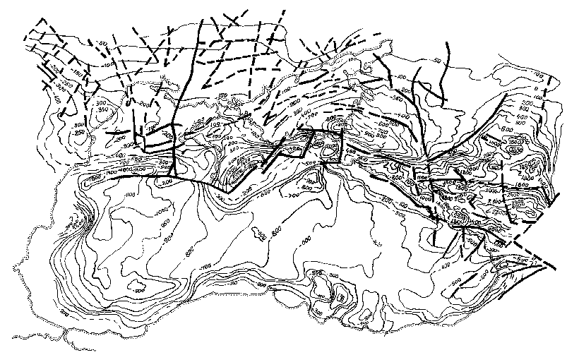
Fig.4
Summary amplitudes of the Azov and Black Sea region recent tectonic movements. Contour lines indicate the summary amplitudes, thick lines indicate faults.
The active tectonic process of the Black Sea deep basin formation was caused presumably by the "passive" lateral subcrust substance movement towards the isostatically upheaving orogenies (based upon the orogeny models of Kober and Vening - Meinesz which were confirmed experimentally by D. Griggs [49] and proved theoretically by T. Tsuboi [50]. The proposed mechanism must be substantiated with additional physical process concept, it can be checked by the re-computation of possible mass transport volumes. At the same time the proposed Azov and Black Sea region new structure formation mechanism is reaffirmed by rather low density of the subcrust substance which seems to be of relic character due to the crust substance sinking into the mantle during the Laramic time in the Rodopy - Pontian suture zone.
Based upon the afore-cited statements as well as the Black Sea basin structure development features during the Cenozoic time and Recent tectonic stage the heterogeneity of the west and east basin segments becomes obvious. By the way it is manifested in the neotectonic movement amplitudes too (fig.4).
Conclusions
These conclusions are based for the most part on the Black Sea basin data and its near northern surrounding. The data available make it possible to define rather distinct differences in the process of the East and West Black Sea basin formation, especially during the pre - Cenozoic time. At the same time the conclusions are referred to the total Black Sea basin because of the common tectonic pattern of the both basins relative to the Mesotethys collision structures, of the common structure features and of the single structure formation till the recent stage time when both basins were developing in the common tectonic mode. It is noteworthy that the Andrusov swell and the Arkhangelsky elevation, being the most characteristic structural feature separating the above-mentioned basins, are manifested as a flexure only in terms of the recent tectonic movements summary amplitudes. Still this separating structure seemed to be a substantial tectonic element in the previous time intervals; it corresponded to the great denudation level possibly restricting the boundary seas of various types as well as their parts with heterogeneous sea bottom.
The main conclusion emerging from the above-mentioned statements is that the Black Sea deep basin, being a new structure, at the same time resulted due to previous tectonic stages progress. It joined the total collision pattern of the Arabian and Eurasian plates as a natural element.
The author wishes to thank A.F.Grachev, V.I.Gromin, M.M.Zubkov , V.A.Kulyndyshev, M.M.Semenduyev for the helpful discussion and assistance.
LITERATURE
1. Белов А.А. Главные домезозойские структурные зоны и история развития Средиземноморского пояса.// Тектоника Средиземноморского пояса.- М.- Наука.- 1980.- С. 55-66.
2. Книппер А.Л. Океаническая кора в структуре Альпийской складчатой области.- М.- Наука.-1975.- 152 с.
3. Баранов Г.И., Греков И.И. Доверхнепалеозойская структура Северного Кавказа.// Тектоника Средиземноморского пояса.- М.- Наука.- 1980.- С. 162-171.
4. Ломизе М.Г. Тектонические обстановки геосинклинального вулканизма.- М.- Недра.- 1983.- 194 с.
5. Муратов М.В. История тектонического развития глубокой впадины Чёрного моря и её возможное происхождение // Бюллетень МОИП, отд. геол.- 1955.- Т.30.- №5.- С.12-19.
6. Сорский А.А. Основные черты строения и развития Кавказа в связи с его глубинной структурой // Глубинное строение Кавказа.- М.- Наука.- 1966.- С. 24-35.
7. Милановский Е.Е. Проблема происхождения Черноморской впадины и её место в структуре Альпийского пояса // Вестник МГУ, серия геол.- 1967.- №1.- С.8-15.
8. Земная кора и история развития Черноморской впадины.- М.- Наука.- 1975.- 360 с.
9. Тектоника мезокайнозойских отложений Черноморской впадины.- М.- Недра.- 1985.- 215 с.
10. Андрусов Н.И. Босфор и Дарданеллы (Исторический обзор мнений об их происхождении) // Землеведение.-1905.- Т.12.- Кн.1-2.-С.5-17.
11. Личков Б.Л. К вопросу о происхождении Чёрного моря // Записки Одесского общества естествоиспытателей.- 1928.- №54.-С.21-28.
12. Ковалевский С.А. Изменения в карсте и гидрографии Крымской Яйлы в связи с историей её развития // Совещание по гидрогеологии и инженерной геологии Крыма (тезисы докладов).- Ялта.- 1959.- С.17-18.
13. Кропоткин П.Н. Механизм движений земной коры // Геотектоника.- 1967.- №5.- С.18-27.
14. Адамия Ш.А., Гамкрелидзе И.П., Закариадзе Г.С., Лордкипанидзе М.Б. Аджаро-Триалетский прогиб и проблема образования глубоководной впадины Чёрного моря // Геотектоника.- 1974.- №1.- С.26-33.
15. Адамия Ш.А., Балавадзе Б.К., Гамкрелидзе И.П. и др. Геолого-геофизические особенности строения коры и верхней мантии Черноморско-Кавказского сегмента Средиземноморского складчатого пояса // Глубинное строение и геофизические особенности структур земной коры и верхней мантии.- М.- Наука.-
1977.- С.25-37.16. Гамкрелидзе И.П. Механизм формирования тектонических структур и некоторые общие проблемы тектогенеза.- Тбилиси.- 1976.- 153 с.
17. Беляевский Н.А., Михайлов А.Е. Строение и происхождение впадины Чёрного моря // Тектоника Средиземноморского пояса.- М.- Наука.- 1980.- С.10-21.
18. Сулиди-Кондратьев Е.Д., Козлов В.В. Деструкция земной коры в зоне сочленения Африкано-Аравийского континента и средиземноморского складчатого пояса // Тектоника Средиземноморского пояса.- М.- Наука.- 1980.- С.40-
49.19. Артюшков Е.В., Шлезингер А.Е., Яншин А.Л. Механизм образования глубоководных бассейнов Средиземноморского пояса // Тектоника Средиземноморского пояса.- М.- Наука.- 1980.- С.10-21.
20. Лебедев Л.И., Маловицкий Я.П., Муратов М.В., Шлезингер А.Е., Яншин А.Л. Сравнительно-тектонический анализ осадочных чехлов глубоководных бассейнов Средиземноморского пояса // Тектоника Средиземноморского пояса.- М.- Наука.- 1980.-С.22-39.
21. Земная кора и история развития Черноморской впадины.- М.- Наука.- 1975.- 360 с.
22. Геология шельфа УССР.Тектоника / Киев.- Наук. думка.- 1987.-152 с.
23. Тектоника мезокайнозойских отложений Черноморской впадины.- М.- Недра.- 1985.- 215 с.
24. Альбом структурных карт и карт мощностей кайнозойских отложений Черноморской впадины. Масштаб 1:1500000 / Ред. Д.А.Туголесов.- М.- ГУГК.- 1989.
25. Геологическая история Чёрного моря по результатам глубоководного бурения / Отв. ред. Непрочнов Ю.П.- М.- Наука.- 1980.- 212 с.
26. Косыгин Ю.А., Кулындышев В.А. Введение в тектоническую картографию.- М.- Недра.- 1981.- 271 с.
27. Шатский Н.С. Некоторые соображения о тектонике Центрального Казахстана // Материалы по геологии Центрального Казахстана (Совет по изучению производительных сил).- М.-Л.- Изд-во АН СССР.- 1940.- С.7-12.
28. Шатский Н.С. Методы составления мелкомасштабных тектонических карт // Избранные труды, т.I.- М.- Изд-во АН СССР.- 1963.- С.447-463.
29. Херасков Н.П. Принципы составления тектонических карт складчатых областей на примере Южного Урала // Известия АН СССР / Серия геологическая.- 1948.- №5.- С.121-134.
30. Тектоническая карта Средиземного моря / Ред. Н.А.Богданов, В.Е.Хаин.- М.- Роскартография.- 1994.
31. Геология и гидрология западной части Чёрного моря / Отв. ред. Я.П.Маловицкий.- София.- Изд-во Болг. Акад. наук.-1979.- 292 с.
32. Чаицкий В.П. О меловом вулканизме северо-западного шельфа Чёрного моря // Известия АН СССР/Серия геологическая.- 1984.- №9.-С.24-30.
33. Вигинский В.А. Новейшая тектоника и тектонические режимы Азово-Черноморского региона // Неотектоника и современная геодинамика континентов и океанов / Тезисы докладов XXIX Тектонического совещания "Неотектоника и современная геодинамика континентов и океанов".- М.- 1996.- С.25-27.
34. Аладатов Г.М., Никифоров Б.М., Шиманский А.А. О распределении докембрийских, палеозойских, триасовых и юрских отложений в Западном Предкавказье // Геологический сборник / Труды КФ ВНИИ, вып.10. - М.- Недра.- 1962.- С.136-148.
35. Борков Ф.П., Головачёв Э.М., Семендуев М.М., Щербаков В.В. Геологическое строение и нефтегазоносность Азовского моря (по геофизическим данным).- М.- ИГиРГИ.- 1994.- С.188.
36. Летавин А.И. Тафрогенный комплекс молодой платформы юга СССР (тектоника, формации и нефтегазоность).- М.- Наука.- 1978.- 148 с.
37. Летавин А.И. Фундамент молодой платформы юга СССР.- М.- Наука.- 1980.- 153 с.
38. Геология СССР // Т.VIII,Крым / Ч.1,геологическое описание.- М.- Недра.- 1969.- 576 с.
39. Шолпо В.Н., Рогожин Е.А., Гончаров М.А. Складчатость Большого Кавказа.-М.:Наука, 1993.- 192 с.
40. Геология Большого Кавказа.- М.- Недра.- 1976.- С.263.
41. Вигинский В.А. Новейшая структура западной части Кавказа и прилегающего Предкавказья и её выражение в геофизических полях./ Автореферат дисс. на соиск. уч. ст. канд. геол.-мин. наук.- М.- ИФЗ АН СССР.- 1986.- 18 с.
42. Вигинский В.А. Новейшая тектоника западно-кавказского сегмента Восточного Паратетиса // Труды I конференции молодых учёных "Геолого-геофизические методы исследования дна акваторий".- Деп. ВИНИТИ № 7939-В85.- С.130-146.
43. Вигинский В.А. Основные этапы развития и ступенчатость рельефа западной части Большого Кавказа и Предкавказья // Геоморфология.-1986.- № 6.- С. 44-53.
44. Чаицкий В.П.,Шелкопляс П.А. Меловые субвулканические, вулканокластические и вулканогенно-осадочные породы южного склона Западного Кавказа и Тамани // Известия АН СССР/Сер. геол.-1986.-№ 3.-С.52-61.
45. Вигинский В.А., Громин В.И., Шиманский А.А. Современное и древнее напряжённые состояния западной части Большого Кавказа // Аэрокосмическое изучение современных и новейших тектонических процессов / Материалы 19 Всесоюзного тектонического совещания.- М.- 1988.- 16-20 с.
46. Белоусов Т.П. Напряжённое состояние земной коры центральной части Северного Кавказа на основе анализа трещиноватости мезозой-кайнозойских осадочных горных пород // Основные проблемы геологического изучения и использования недр Северного Кавказа (материалы VIII Юбилейной конференции по геологии и полезным ископаемым).- Ессентуки.-1995.-С.292.
47. Артемьев М.Е.,Голланд В.Э.,Ниаури Г.А. Новые данные по изоостазии Кавказа // Известия АН СССР/Физика Земли.- 1985.- №2.- С.3-15.
48. Яковлев Ф.Л. Исследование кинематики линейной складчатости (на примере юго-восточного Кавказа) // Геотектоника.- 1987.- №4.- С.31-48.
49. Griggs D. A theory of mountain-building // Amer. Journ. Of Sci. - 1939.- V.237.- № 9.- P. 611-649.
50. Цубои Т. Гравитационное поле Земли.- М.- Мир.- 1982.- 288 с.